About Belize
Belize is located in the Northern Hemisphere, within Central America.
Belize is bounded on the North by Mexico, South and West by Guatemala, and the beautiful Caribbean Sea washes its 174 mile coastline to the East.
Geographically we're located between 15° 52' 9" and 18° 29' 55" North Latitude, and 87° 28" and 89° 13' 67" West Longitude with an area of 8,866 sq. miles including 266 sq. miles of islands.
Geography
The cayes (pronounced keys), the offshore atolls, and the barrier reef are on of the main attraction to Belize. The barrier reef, which is 185 miles long, is the longest in the Western Hemisphere. The cayes are islands that are located between the mainland and the barrier reef, on the barrier reef, and on or within the barrier reef perimeters of the offshore atolls.
Although the mangrove cayes are normally uninhabitable by humans, they do provide a superior habitat for birds and marine life. Many birds, fish, shellfish, and marine organisms begin their lives within the protection of the mangrove. On the other hand, the island cayes, which are distinguishable by their palm trees, have provided the foundation for the development of many fine resorts to serve the water sports enthusiasts and the marine naturalists. The cayes and atolls provide superior opportunities for SCUBA diving, snorkeling, fishing, boating, sailing, kiteboarding, and sea kayaking, as well as habitat for both nesting birds and turtles.
The northern half of the mainland of Belize is a plain that was once the bed of the sea. The land is covered with a thin layer of soil that supports scrub vegetation and dense hardwood tropical forest. The coastal area is neither land nor sea, but a sodden, swampy transition between the two. It consists of mangrove and grasses, and is bordered by tussock grasses, cypress, and sycamore where the land separates the water.
The central part of Belize consists of sandy soil that supports large savannas. Approximately thirty miles southwest of Belize City, the land begins to rise dramatically to between 1,500 and 3,680 feet above sea level into the enchanting Mountain Pine Ridge Area and the Maya Mountains. Abundant rainfall runs off the highlands of the west in a number of streams which flow into the Macal River. Ultimately, the Macal River and the Mopan River converge to provide the headwaters of the Belize River.
The southern part of Belize, with its watershed to the southeast from the Maya Mountains, consists of short rivers that rush through slopes combed with overhanging ledges and caves. The rivers, carrying sand, clay and silt, have enriched the coastal belt over the years, allowing Belize to develop significant agricultural products, such as citrus and bananas. Along with an annual rainfall of some 170 inches, Southern Belize has a true tropical rain forest that is rich with ferns, palms, lianas, and tropical hardwoods.
Climate
The climate is subtropical, with a brisk prevailing wind from the Caribbean Sea. The country has an annual mean temperature of 79 degrees Fahrenheit, and the humidity is nicely tempered by the Sea breezes.
Variations in weather features emphasize the interesting difference in elevation, geology, plant and animal life. A summer high temperature usually never exceeds 96 degrees Fahrenheit, and winter lows are seldom below 60 degrees Fahrenheit--even at night.
Saltwater temperature varies between 75 degrees Fahrenheit and 84 degrees Fahrenheit.
Annual rainfall ranges from 50 inches in the north to 170 inches in the south. Although the rainy season is usually between June and August and the dry season is between February and May, global weather changes are making predictions somewhat invalid. At the end of October the weather does become cooler, and from November to February it is pleasant with scattered showers of rain. Average humidity is 85 percent.
Government type
Parliamentary Democracy
Religions
Roman Catholic 62%, Protestant 30% (Anglican 12%, Methodist 6%, Mennonite 4%, Seventh-Day Adventist 3%, Pentecostal 2%, Jehovah's Witnesses 1%, other 2%), none 2%, other 6% (1980)
Languages
English is the official language
Government
Belize achieved full independence on the 21st of September 981. It is now a member of the British Commonwealth, the United Nations and Caribbean Community (CARICOM).
Court System
The laws of Belize is based on the English legal system together with locally enacted legislation. There are three levels of the judiciary present in the country of Belize. These are: a) the Magistrate Court, b) the Supreme Court, and c) the Court of Appeal. The final appelete court is located in Trinidad and Tobago and is known as the Caribbean Court of Justice (CCJ).
There are six districts in Belize. Each of the six judicial districts has a summary jurisdiction court (criminal division) and a district court (civil division), both of which are presided over by a magistrate.
Currency
In Belize the currency is known as the Belize Dollar (Bze). The fixed rate of exchange for the Belize Dollar is BZE. $2.00 to USD $1.00.
Belize Financial Institutions - Banks:
There are five local commercial banks in Belize, these are:
- Belize Bank Ltd.
- First Caribbean Bank
- Bank of Nova Scotia; and
- Atlantic Bank Ltd.
- Heritage Bank
The International Banks in Belize are:
- Heritage International Bank Ltd
- Atlantic International Bank Ltd
- Choice Bank Ltd
- Caye Bank Ltd; and
- British Caribbean Bank Ltd.
The Central Bank was created to replace the Monetary Authority of Belize.
Roads in Belize
Belize has four major highways, the Northern Highway connecting Belize City with Chetumal on the Mexican Border, the Western Highway connecting Belize City with Belmopan and continuing to the border with Guatemala, the Southern Highway linking the Stann Creek and Toledo Districts and the Hummingbird Highway. All principal towns and villages are linked by roads to Belmopan and Belize City.
Regular bus services operate to and from all main towns.
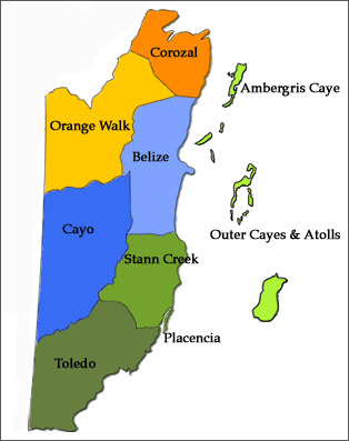
Belize Districts
There are six districts in Belize, these are:
- Belize District
- Cayo District
- Corozal District
- Orange Walk District,
- Stann Creek District, and
- Toledo District